
[ad_1]
A detailed trekking guide covering everything you need to know about the Manaslu Circuit Trek in Nepal.
The Manaslu Circuit Trek is one of the world’s most spectacular tea house trekking itineraries. Following a circuit route of the magnificent and unspoiled Manaslu Region of Nepal, this trek offers pristine Himalayan views, a high altitude pass crossing above 5,100 meters at the Larkya La Pass, and exposure to the unique and fascinating Tibetan culture.
In this comprehensive guide, I’ll cover everything you need to know about trekking the Manaslu Circuit, from forming an ideal itinerary to a day-by-day breakdown of what to expect based on my experience on the trek.
- About the Manaslu Circuit Trek
- Booking a Trekking Guide for the Manaslu Trek
- Manaslu Circuit Trek Itinerary
- High Altitude Trekking Insurance for the Manaslu Trek
- Manaslu Circuit Map
- What to Expect on the Manaslu Circuit Trek
- Day 1: Drive from Kathmandu to Maccha Khola (830 m)
- Day 2: Trek from Maccha Khola to Jagat (830 m)
- Day 3: Trek from Jagat to Deng (1,804 m)
- Day 4: Trek from Deng to Namrung (3,480 m)
- Day 5: Trek from Namrung to Shyala (3,480 m)
- Day 6: Trek from Shyala to Samagaon (3,530 m) via Pungyen Monastery (4,070 m)
- Day 7: Rest Day in Samagaon (Side-Trip to Manaslu Base Camp at 4,800 m)
- Day 8: Trek from Samagaon to Samdo (3,860 m)
- Day 9: Rest Day at Samdo (Side-Trip to Tibetan Border, Lajyang Bhanjyang – 5,030 m)
- Day 10: Trek from Samdo to Dharamsala/Larke Phedi (4,460 m)
- Day 11: Trek from Dharamsala to Bhimtang (3,720 m) via Larkya La Pass (5,106 m)
- Day 12: Trek from Bhimtang to Tilje (2,300 m)
- Day 13: Jeep from Tilje to Kathmandu (9 hours)
- What to do in Kathmandu After Trekking the Manaslu Circuit
- Where to Stay in Kathmandu Before & After the Trek
- Things To Know About the Manaslu Circuit
- Packing List for the Manaslu Circuit Trek
- FAQ About Trekking the Manaslu Circuit in Nepal
- More Nepal Trekking & Adventure Guides

About the Manaslu Circuit Trek
The Manaslu Circuit is a breathtaking trekking route located in the majestic Himalayas of Nepal. Beginning in the green Himalayan foothills, the trek journeys around the eighth-highest mountain in the world, Mount Manaslu (8,163 m), and crosses over a high alpine pass to finish in the Annapurna Region.
- Typical Trekking Itinerary: 13-15 Days
- Total Distance: 175 km
- Total Elevation Gain: 9,800 m
- Maximum Elevation: 5,100 m
- Difficulty: Moderate
- Trekking Seasons: March-May & September-November
- Cost: $900-$3,000 USD
The Manaslu Trek is a unique and less crowded alternative to the well-known Annapurna Circuit Trek and Everest Base Camp Trek– offering a moderate trekking challenge and world-class views while staying in authentic Nepali tea houses– without the espresso machines and hot towels.
Along the way, you’ll pass over huge suspension bridges leading to remote villages where the Buddhist traditions and customs of Tibetan Culture have been preserved. Other highlights include epic day trips to the ancient Pungyen Gompa, tucked away at the end of a pristine glacial valley, a side trip to Manaslu Base Camp (4,800 m), and a long journey to the Nepal – Tibetan Border at 4,900 m.

Booking a Trekking Guide for the Manaslu Trek
I trekked the Manaslu Circuit with my favorite local trekking company– Himalayan Masters, which is who I organize all my treks with in Nepal.
Himalayan Masters is a small company run by my good friend Sandip, who was born near the Manaslu Region but now has a small office in Thamel, Kathmandu. I have no problem recommending this company as they pay their guides and porters 25% more than others. Sandip also gives back to the local community by building schools and investing in other community projects– while still offering a very competitive price for their treks, especially compared to big international trekking companies.
You’ll also get 5% OFF any of the treks or tours with Himalayan Masters by using code OLLY5 at checkout.
Email: [email protected]

Tip: While it was once possible to trek independently, hiring a local guide is now compulsory for the Manaslu Circuit Trek following the April 2023 regulatory changes.
Manaslu Circuit Trek Itinerary
The most popular Manaslu Circuit itinerary runs between 13-14 days, with the first and last days involving a jeep or local bus drive from and to Kathmandu.
Below is the most common itinerary which we followed and includes all the Manaslu trekking highlights such as the Pungyen Gomba, remote villages, Birendra Lake, Manaslu Base Camp, Tibetan Border, and the Larkya La Pass.
| Day | Route | Time | Sleep Altitude |
|---|---|---|---|
| 1 | Jeep from Kathmandu to Maccha Khola | 7 hours | 830 m |
| 2 | Trek from Maccha Khola to Jagat | 6-7 hours | 1,410 m |
| 3 | Trek from Jagat to Deng | 7-8 hours | 1,804 m |
| 4 | Trek from Deng to Namrung | 6-7 hours | 2,630 m |
| 5 | Trek from Namrung to Shyala | 4-5 hours | 3,480 m |
| 6 | Trek from Shyala to Samagaun via Pungyen Monastery (4,050 m) | 4-5 hours | 3,530 m |
| 7 | Rest Day in Samagaun with Side-Trip to Manaslu Base Camp (4,800 m) | 7 hours | 3,530 m |
| 8 | Trek from Samagaun to Samdo | 2.5-3 hours | 3,860 m |
| 9 | Rest Day at Samdo with Side-Trip to Tibetan Border (5,030 m) | 8-10 hours | 3,860 m |
| 10 | Trek from Samdo to Dharmasala | 2.5-3 hours | 4,460 m |
| 11 | Trek from Dharmasala to Bhimtang via Larkya La Pass (5,106 m) | 8 hours | 3,720 m |
| 12 | Trek from Bhimtang to Tilje | 5-6 hours | 2,300 m |
| 13 | Jeep from Tilje to Kathmandu (9 hours) | 9 hours | 1,400 m |
It is also possible to extend this trek by including more overnight stays in villages between, or by adding the Tsum Valley Trek as an extension. Remember, most trekking companies recommend at least one rest day upon reaching altitudes above 3,400 meters to aid in acclimatization and avoid any issues later on.
Manaslu Circuit Elevation Chart (13-Day Itinerary)
The great thing about the Manaslu trekking circuit is that it offers a decent elevation profile to prepare for the high elevation pass beyond 5,100 meters. Below is an elevation chart to help you understand what to expect from this Manaslu Circuit itinerary.

High Altitude Trekking Insurance for the Manaslu Trek
Since most travel insurance companies void their coverage as soon as you step over 4,500 meters above sea level, it might be a good idea to consider specialized trekking travel insurance options.
This is a very contested topic in the Himalayan trekking and climbing community, but in my experience, these three options that might be worth checking out.
- Global Rescue Membership – helicopter rescue membership with no altitude caps. One of the most popular options in Nepal.
- World Nomads – offers peace of mind travel insurance. Check their PDS for options related to high-altitude trekking.
- Heymondo – my new favorite general travel insurance policy with affordable prices and an excellent app. Has an altitude cap of 5,000 meters, so you may not be covered for the Larkya La Pass.

Manaslu Circuit Map
Below is a general Manaslu Circuit Trekking map that can be useful for your trip. However, paper maps are available for purchase in Thamel, or will be provided to you for free if you book your trek with Himalayan Masters as I did.
GPX: Check my Strava

What to Expect on the Manaslu Circuit Trek
Wondering if the Manaslu Circuit is the right Nepal tea house trek for you?
Below is a detailed breakdown of my 13-day Manaslu trekking itinerary from Kathmandu to help you decide. Himalayan Masters helped us tailor this itinerary to suit our fitness levels and experience. Remember, you can always adjust to suit your needs.
Day 1: Drive from Kathmandu to Maccha Khola (830 m)
On the first day of the trek, there is actually no trekking at all. That’s because this day will involve transport from your hotel in Kathmandu Valley to the Manaslu Circuit starting point in Maccha Khola, approximately 160 km (100 mi) from Kathmandu.
There are two options for this– either take the local buses (12-hour journey), or arrange a private Jeep with your trekking operator (7-8 hours). If you’ve spent any time on long-distance buses in Nepal, you’ll know that these offer far from a pleasant journey. However, if you want to save a few thousand rupees, taking the public buses is the cheaper option.
Booking this trip with Himalayan Masters, we were offered the private Jeep, which we were more than thankful for once we got onto the road.

For the most part, the road conditions are well-developed and sealed, at least until the final two hours. From here, it gets progressively bumpy and admittedly a little sketchy as the dirt road clings onto the steep banks of the Budhi Gandaki River. In the final sections past Soti Khola, there were some landslides where we had to wait to be cleared.

Until just recently, trekkers would begin the Manaslu Circuit with an overnight stay in Soti Khola. However, these days it’s better to start trekking from Maccha Khola since the road has been extended.
Maccha Khola Village (1,410 m)
Maccha Khola is quite a large village considering its remote location. Perched on the banks of the Budhi Gandaki River, this village has several tea houses & lodging offering accommodation and meals. We stayed at the Hotel Chum Valley Restaurant and Lodge, a three-story lodge with comfortable but basic amenities.
Arriving at 3:30 pm, we had plenty of time to explore the village and catch up on some rest after the bumpy car ride.

Day 2: Trek from Maccha Khola to Jagat (830 m)
- Trekking time: 6-7 hours
- Elevation: 900 m ascent, 400 m descent
- Distance: 20 km
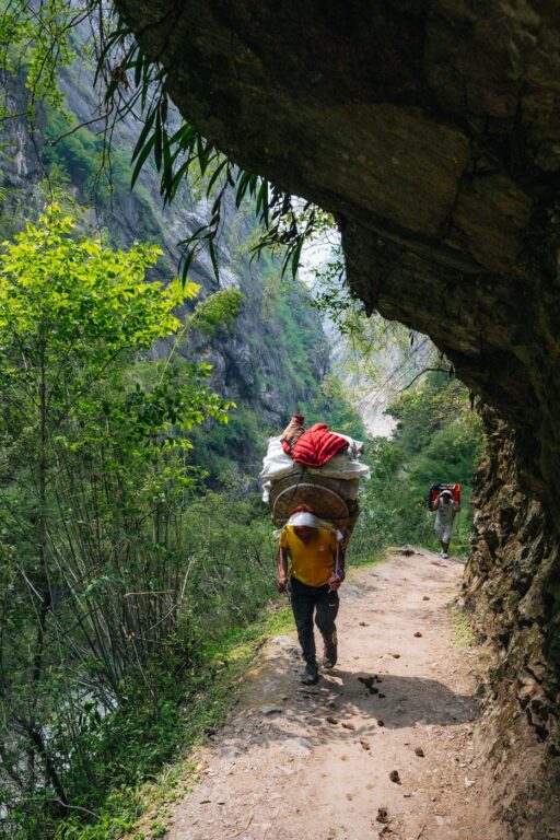
Day 2 on this Manaslu Circuit itinerary marks the first day of trekking. Beginning the trek on a beautiful clear morning, we admired the views of the snow-capped peaks guiding our direction. For the first two hours, the route follows the unsealed road carved into the cliffs high above the river. This road doesn’t see much traffic, with only a handful of local tractors and two trucks passing us.

The road is very easy to follow and climbs ever so gently that it’s almost hard to tell you’ve gained any altitude at all. However, due to the relatively low elevation, this first trekking day is typically quite hot and sweaty.

After about two hours of walking, we arrived at a small village named Tatopani. This literally translates to hot water from Nepali and is so named for the warm natural thermal pools. Locals have constructed a small public bath along the side of the trail, with a tap offering warm, flowing water for washing.

First Suspension Bridge at Tatopani
Immediately after Tatopani, we crossed the first suspension bridge over to the east side of the river, leaving the road behind until we joined back with it at Jagat later that afternoon.

The rest of the day followed a beautiful green trail, passing many small villages beside the river.

Lunch Stop at Thulo Dhunga
For the first lunch stop, we chose Thulo Dhunga, a very small village with just one tea house. The name Thulo Dunga means big stone, named after the huge boulder behind the village. After a hearty meal, we continued on, climbing gently up the overgrown rocky slopes to an exposed landslide area. This trail then navigated the rocky scree, following a narrow trail somehow holding onto the ever-moving earth.


This was the first exposed section of the Manaslu Trek that was a little hairy, but easily manageable. Soon, we entered stable ground again as the banks leveled out, allowing for green forests and trees to grow. Soon, we passed the scenic Yaruphant village, where we got an amazing vantage point of the widening Budhi Gandaki River before dropping down to the riverbank. After a couple more suspension bridges, we crossed the river again and met up with the road.


This is when we finally arrived at the official entry point to the Manaslu Conservation Area, marked by nothing more than a small, insignificant sign on the side of the road. Just a few hundred meters beyond, we arrived at Jagat.

Jagat Village (1,410 Meters)
Jagat is a small village perched above the west bank of the river. It features a main cobblestone street lined by rock sleet-roofed stone huts leading to a main square, where you’ll find a large mani stone. There is also an official Manaslu Conservation Area entrance point here where officials will check your permits.
Arriving at the village, we stayed at the Jagat Guest House, another basic but more than adequate accommodation with a great rooftop terrace view. There is grid power available in Jagat, but the cell data internet with Nepal Telecom did not work.


Day 3: Trek from Jagat to Deng (1,804 m)
- Trekking time: 7-8 hours
- Elevation: 1,100 m ascent, 580 m descent
- Distance: 22 km
Following a comfortable rest at Jagat, we departed early in the morning following a hearty breakfast. Leaving Jagat, the trail opened up to reveal the wide river expanse. There is a large basin housing three separate waterfalls here which made for some great photos. Looking up on the hill above, we also noticed a hydroelectric facility.


Continuing on, we passed the village of Salleri, where the trail joined back with the newly constructed vehicle access road carved into the perpendicular cliffs on the west bank.


After 1.5 hours, we departed the road once and for all, ducking down to a quaint village with grazing animals and a scenic wooden bridge.

Shortly after, we crossed a long suspension bridge to join the trail on the eastern side of the river before climbing a short series of switchbacks on a mule trail beside bamboo forests leading to Philim Village.

Arriving at Philim Village Checkpost
Philim is a vibrant village with spectacularly beautiful buildings. Arriving early in the morning, we noticed many children of all ages rushing to a local school. There is also a Manaslu Conservation Area checkpost in Philim, where we enjoyed a short break while waiting for our guide to show the paperwork.

After Philim, the trail edges the cliffs of Budhi Gandaki’s east bank, undulating lightly as the scenery becomes more rugged and beautiful.
Lunch Break at Chisopani
Today’s lunch spot is a very small village of Chisopani. We spent an hour here enjoying the warmth of the sun and refueling before the long stint to Deng.

The Confluence of the Budhi Gandaki & the Shar Khola
Continuing on from Chisopani, the trail undulates consistently through sparse pine forests along the cliff, passing a series of landslide areas where the trail is somehow holding on. This area is remarkably beautiful, with scenes of waterfalls spilling from the cliffs above and tiny villages clinging high on the slopes.
Soon, we arrived at the confluence of the Budhi Gandaki and the Shar Khola, marked by a long and very high suspension bridge. For the Manaslu Circuit Trek, you’ll take the left path, crossing the bridge and continuing on into the forest. The right path (straight ahead), leads to Lokpa in the Tsum Valley, a scenic 5-7 day side-trip itinerary.

Next, the trail passes the small villages of Nyak and Pewa, following a densely forested section beside the river, undulating consistently at around 1,800 meters in elevation.
This last section is quite long, taking us about three hours from the suspension bridge turnoff. However, it was also one of the most beautiful sections of the trek so far, with the sounds of birds and the roaring river guiding us toward Deng.


Deng Village (1,804)
Deng (also written as Dyang), is another small village with a few tea houses and lodges.
It is positioned in an ideal location at the confluence of the Budhi Gandaki and the Deng Khola, offering clear mountain views. We stayed at the Windy Valley Guest House, which offered free charging in the room. There is limited internet connectivity here, but we managed to get a message out with our Nepal Telecom sim.

Day 4: Trek from Deng to Namrung (3,480 m)
- Trekking time: 6-7 hours
- Elevation: 1,400 m ascent, 600 m descent
- Distance: 19 km
Waking to an incredibly clear morning, we admired the dancing light on the jagged, glacier-capped peaks in the distance before setting off towards our next destination, Namrung. Namrung is approximately 19 kilometers from Deng, with a fair bit of total elevation gain coming from a constantly undulating trail.

To start, we continued on the west bank of the river, again tracing the route of the Budhi Gandaki before crossing another suspension bridge. From here, the trail continued on the east side for roughly four hours before arriving at our lunch spot in Gap.


This trail snakes its way along the cliff, again passing many sections of warn landslide-prone areas. We stopped briefly at a particularly scenic spot to enjoy hot tea and biscuits.

Lunch Stop at Gap (Ghap)
Gap (also written as Ghap), is quite a large village compared to the others we’d passed so far. At the entrance to the village, there is a small steel bridge, where we watched some langur monkeys swinging across.
We chose a beautiful lunch spot where we enjoyed a delicious lunch and a strong LTE connection. Again, we enjoyed the sun, soaking in its life-giving rays knowing that in just a few days we’d be missing its warmth dearly.
After lunch, we continued on from Gap, where the trail evened out for about an hour before entering a beautiful fir and rhododendron forest full of birds.

Fir & Rhododendron Forest to Namrung
The trail through this forest was incredibly beautiful, and a clear highlight of the Manaslu Circuit Trek’s lower elevated sections. The trail follows the northern banks of the river, passing very close to its mighty flow.
After approximately 1.5 hours from Gap, we arrived at a suspension bridge that again crossed to the southern side and marked the steep ascent to Namrung. There are concrete steps carved into this route, making the climb quite easy to manage and enjoyably.

Approaching Namrung, we passed some very long mani walls in the forest, with Tibetan mantras carved into their stone.

Namrung Village (3,480 m)
Namrung is another beautiful village and a former customs post from the times when the Manaslu region was a primary path for the Tibetan salt routes.
There is a huge waterfall just outside of town, with a few well-kept tea houses offering comfortable accommodations and delicious food. Again, there are power lines running all the way up this Manaslu trek, which means we had charging available for free in the rooms.
However, the internet was limited, with a weak connection only capable of sending a message out on Nepal Telecom lines.

Day 5: Trek from Namrung to Shyala (3,480 m)
- Trekking time: 4-5 hours
- Elevation: 1,100 m ascent, 350 m descent
- Distance: 16.5 km
Day 5 on the Manaslu Trek begins with an easy and pleasant walk departing Namrung. Immediately, we crossed a small wooden bridge and walked through a gate welcoming trekkers into the Chumnubri area. This stretch offers good opportunities to spot the mighty Himalayan mountains of Siring, the Ganesh Himal, and Mount Himal Chuli.

From this point on, we enjoyed the dramatic views of the surrounding Nubri mountains guiding us onwards passed the village of Bhaniam as we trekked along the barley fields. This was a very scenic section of the circuit, passing through pine forests surrounded by tall cliffs with behemoth waterfalls on either side.


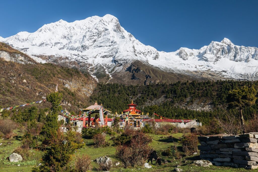
Arriving at the hilltop village of Lhi, there is a small colorful Gompa (monastery), draped in prayer flags and surrounded by beautiful forest.


As we continued on, the Tibetan influence was becoming more apparent in every village, with more frequent Stupas, prayer flags, and mani walls.

After approximately an hour, we began the gentle switchback climb to a small hill topped by a white stupa. This is where we enjoyed a small tea break, admiring the views of the river valley below us.
From this hillside viewpoint, we continued on, climbing gently as we passed Shyo along with some other villages consisting of no more than three or four houses.

Lunch Stop at Lho Village
Lho is a large village with a strong Tibetan Buddhist influence. Mani walls leading to stepped chortens surround the village, along with several small Stupas scattered amongst the stone huts. The colorful hilltop Gompa leads the way into the village, framed elegantly by a mountain backdrop that would have been incredible if it weren’t for the early monsoon clouds concealing their might.
When we visited, we noticed extensive construction works, which our guide told us were a part of the new Lho monastery works. It was just 4 hours of relatively easy trekking to reach Lho, which made for an excellent lunch spot before continuing up the hill to visit the Nyiangmapa Monastery.

Lho Gompa (Nyiangmapa Monastery)
Being one of the shorter days on the Manaslu Circuit trek, we had plenty of time after lunch to explore Lho’s famous hilltop Gompa. This is situated on a small hilltop approximately 100 meters above the village, accessible by a gentle, forested switchback trail.
The Gompa was under construction when we visited, but we had the opportunity to enter the main monastery area to see the beautifully decorated interior.

Easy Forest Climb to Shyala
From the Nyianmapa Monastery, we walked for approximately 1.5 hours, first descending slightly before climbing the final 200 meters of altitude to Shyala Village. This section again entered a misty rhododendron forest, following a crystal-clear river stream.

Shyala Village (3,480 m)
Shyala is one of the largest villages within the Manaslu Conservation Area. There are plenty of tea houses and lodges lining the main street, along with a big prayer mill and the large Shree Lho Primary Syala School. On the hilltop, there is another large Gompa offering excellent views of the village and surrounding mountain peaks.


Our overnight stay that night was the cottage-style Nubri Shala Guest House at the end of the village. Unfortunately for us, the rain clouds gathered in the afternoon, which meant we missed the impeccable Himalayan mountain views promised at Shyala.
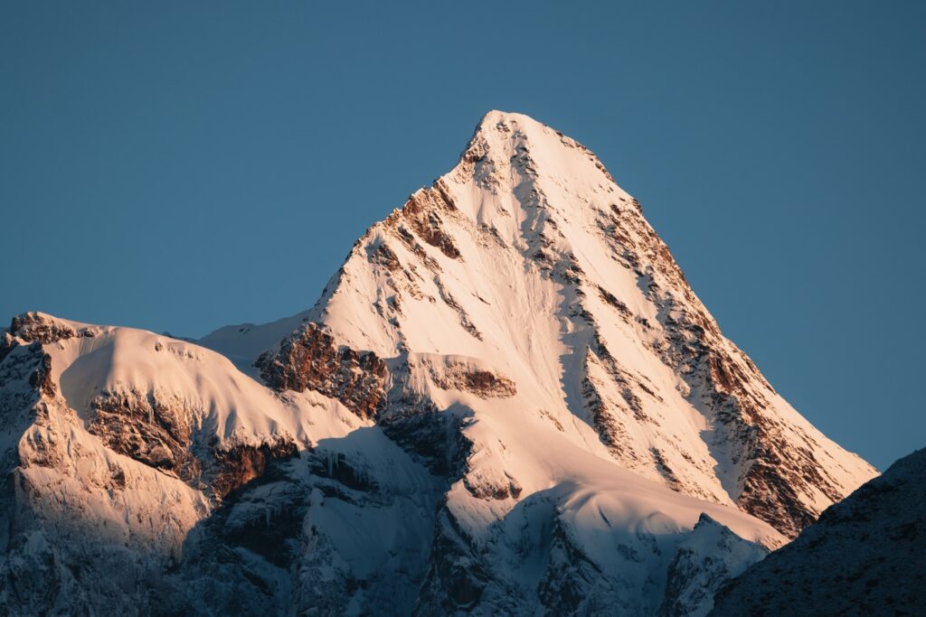
However, this misfortune was more than paid for when we woke up the following morning to bluebird skies and 360-degree Himalayan views. Notable mountains visible from Shyala include Mt. Manaslu (8,163 m), Himal Chuli (7,893 m), Harka Gurung Chuli or Peak 29 (7,871 m), and the jagged peaks of the Pangbuche Himal.


Day 6: Trek from Shyala to Samagaon (3,530 m) via Pungyen Monastery (4,070 m)
- Trekking time: 6-7 hours
- Elevation: 750 m ascent, 700 m descent
- Distance: 17 km
If a 5:00 am alarm is ever worth it, it is at Shyala. After taking in the magnificent mountain views while sipping hot coffee from the lodge, we continued on.

Side Trip to Pungyen Gomba
Today, we took a side trip up to the Pungyen Gomba, situated at 4,050 m at the end of the Pungyen Valley.
The plan was to pack a light bag, leaving the rest of our gear at Shyala, where we’d return for lunch before continuing on to Sama (Samagaon). We took the newly constructed route to the monastery, climbing beside the Shyala hilltop monastery, through the dense forest and up to the long, plateauing valley.


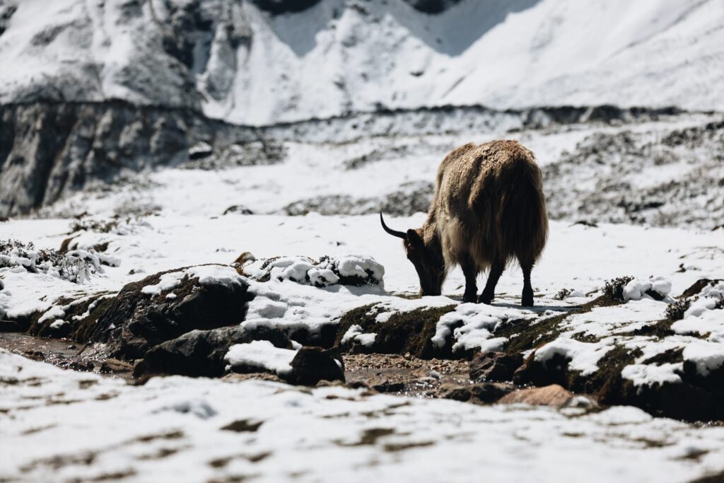
This side trip was easily the most scenic of the Manaslu trek so far, offering unimaginably clear views of the mighty Mt. Manaslu, the eighth-highest mountain in the world. Along the way, we passed many grazing yaks and spotted some massive vultures flying overhead.


Due to some heavy rain the night before, we were also forced to rock-skip over some lofty streams before gaining the valley. The Pungyen Gomba sits right at the end of the valley, with some small stone huts carved into the mountainside. For us, it took approximately 2.5 hours at a steady pace, with many photo stops.

The Pungyen Gomba (4,050 m)
The Pungyen Gomba is one of the oldest Tibetan monasteries in the Manaslu Region. It was built by some of the earliest Tibetan settlers, known as the Nubri people, who migrated to this part of the Himalayas over 400 years ago. The monastery borrows the name of Pungyen, which is the old Nubri name for Manaslu (Manaslu also goes by the name Kutang).


Unfortunately, the Gomba was closed when we arrived. However, we did manage to get a good peak through the window. Our guide then offered us some tea and biscuits beside the monastery, taking in this amazing scene in front of us.

On this clear mid-morning, we were offered clear 360-degree panoramic views of some of the Himalayas’ most impressive peaks, including Mt. Manaslu (8,163 m), Ngadi Chuli (7,871 m), Siringi Himal (7,155 m), and Himal Chuli (7,893 m).
We were told that it was also possible to continue up the valley towards the edge of the Pungyen Moraine, but we decided to turn back instead.


Return to Shyala for Lunch
Instead of doubling back on the same route, we decided to take the old route back down. This branched left near the start of the flat area, descending steeply beside a muddy river. Once we reached the main Manaslu Circuit Trail again, we turned right and walked approximately 45 minutes back to Shyala.
Alternatively, we could have also turned left, arriving at our evening destination earlier, since it’s just a 30-minute walk from here. However, we didn’t mind doubling back to Shyala, especially after tasting the delicious Sherpa Stew that waited for us once we arrived.

Trek from Shyala to Samagaun (Sama)
The final mission for the day was an easy walk to Samagaun Village (also referred to as Sama), just 1.5 hours from Shyala. We followed the same trail we’d just come from, climbing slightly and crossing two suspension bridges before dropping down back to Samagaun.

Samagaun Village (3,530 m)
Samagaun is the largest village in the Manaslu region. Entering the village, we passed a beautiful school nested beside a yak grazing field. Soon, the rugged path turned to a winding stone road, passing many stone houses. There is also a police checkpost here where your guide will need to show your special permits.
Samagaun Village is like nowhere else I’ve visited in Nepal. Contrasting with the commercialized Everest Base Camp Trek, this village is as authentic as it gets. Groups of cheeky children running through the fields, men tending to new stone constructions, and women carrying babies in hand-woven baskets. Even with our modern comforts, I couldn’t help but feel envious of these smiling people, living peacefully in the present.
We stayed at the upscale “Norling Hotel”, owned by Mingma Lama, the first person from the Ghorka district to summit the main peak of Manaslu. The lodge had reliable charging in the room, a large rooftop dining hall with a balcony, and wifi available for 500 rupees.
NTC sim cards were able to fetch an “Edge” connection to get a text out.

Day 7: Rest Day in Samagaon (Side-Trip to Manaslu Base Camp at 4,800 m)
- Trekking time: 6-8 hours (depending on snow)
- Elevation: 1,350 m ascent, 1,350 m descent
- Distance: 13.2 km
Today we awoke early for the big push-up to Manaslu Base Camp at 4,800 m. This is another optional side trip with quite a big elevation gain. The possibility of reaching Manaslu Base Camp depends highly on the amount of snow on the slopes and favorable weather conditions.
Following a big breakfast, two of us headed up for the steep ascent, while others preferred to enjoy a day relaxing by Birendra Lake.
Birendra Lake
Along the way, it’s also possible to take a short walk of just 45 minutes to the lake. While I headed up for the base camp push, Haylea enjoyed a relaxing day by the rocky banks of the lake. To get here, you’ll trek through the monastery at the end of the village instead, turning left up and over the hill, then over the moraine hill to the clear, blue glacial lake.
This is one of the most scenic places on the Manaslu Circuit Trek, and a great place to relax and recover.

Tip: It is also possible to visit Birendra Lake on the way to Manaslu Base Camp. However, you’ll need to cross the lake outflow, which is possible in the dry season on sunny days.
Climbing to Manaslu Base Camp
From Samagaun, the journey to Manaslu Base Camp beings with a flat stretch lasting approximately 15 minutes. Next, we turned west towards Manaslu Peak and began the gentle climb for about 45 minutes. As we broke through the treeline, we had amazing views of the Birendra Lake below. As the trail progresses, the terrain becomes more challenging, ending with a steep ascent featuring zig-zagging switchbacks.


During the climb, we were rewarded with incredible vistas of the majestic Manaslu Peak beneath the slowly disappearing Manaslu Glacier. The sight of massive chunks of ice cascading into the serene Birindre Lake is truly mesmerizing. Owing to a clear day, we also spotted the mighty Yangra (Ganesh I at 7,422 m) of the Ganesh Himal in the distance.
Soon, we reached the ever-deepening snowy slopes. Depending on the season and conditions, there may be significant snowfall, making the path challenging to traverse.

Unfortunately, we had to turn back at around 4,620 meters. While we had less than a kilometer and 200 meters of elevation to reach Manaslu Base Camp, the snow was at least a meter deep, reducing our speed to a crawl. Regardless, we considered the side trip a success and made the long descent back to Samagaun.


Looking to Step it Up?
Why not check out my guides to climbing Mera Peak (6476m), or Island Peak (6,189 m), two of Nepal’s best trekking peaks? These are great entry-level summits in the Khumbu requiring no prior mountaineering experience.
Day 8: Trek from Samagaon to Samdo (3,860 m)
- Trekking time: 2.5-3 hours
- Elevation: 410 m 60 m descent
- Distance: 9.1 km
Following quite the eventful “rest day”, the eighth day of the Manaslu Trek is a much better definition of the term than the day prior. We awoke nice and early to enjoy the magnificent mountain views from the Norling Lodge rooftop, where we sat for several hours enjoying hot coffee and a pancake breakfast.

Nubri Pema Decho Ling Monastery
On the way out of Samagaun, we stopped by the beautiful old Gompa just above Samagaun. Luckily for us, the doors were open, and we were permitted to enter. This is a very ancient monastery, tracing the Lama lineage of Rō. Inside there was a small informational board showing this lineage dating back to the first Tibetan to settle here in the 1600s.
After exploring the old Gompa, we walked over to the new Gomba area called Padmasambhava Park. This was still under construction when we visited. However, we were lucky to be welcomed inside, where we admired the amazing works of art hanging on the walls, which we were told came from Tibet.


Enjoyable Trek to Samdo
The trek to Samdo is a very easy and pleasant hike, following the river deeper into the valley along wide grassy fields and shrublands.
Along the way, we passed an enormously long mani wall, framing the path perfectly below the mighty peak of Pangpoche Himal (Panboche I – 6,620 m). Having plenty of time, we enjoyed a long tea break in a grassy area, where we watched the grazing yaks and marmots scurrying through the field.
The final push to Samdo requires a short burst of elevation after crossing a wooden bridge over the river.

Samdo Village (3,860 m)
Samdo is a very small village, marked by a white stupa at the entrance. There are only a few lodges here, a stark contrast to the almost bustling atmosphere at Samagoan. We decided to stay at the Yak Hotel, which offers incredible river and mountain views, a warm dining hall, and comfortable beds.
Electricity is limited in Samdo. However, when we visited there were ongoing works to get an electrical grid connected to Samdo from Samagoan. NTC service is very limited, but Yak Hotel offers wifi (sometimes works) for 500 rupees.

Acclimatization Hike to Samdo Ri
To prepare for the following days’ altitude gain, many choose to take the steep climb up the slopes of Samdo Ri. This trail picks up at the opposite end of the village, marked by a flagpost and prayer flags. The altitude of Samdo Peak is over 5,100 m, so it is not recommended to climb to the very top. However, there are prayer flags situated at roughly 100 m increments.


Day 9: Rest Day at Samdo (Side-Trip to Tibetan Border, Lajyang Bhanjyang – 5,030 m)
- Trekking time: 8-10 hours
- Elevation: 1260 m ascent 1260 m descent
- Distance: 19.5 km
While many people choose to continue directly to Dharmasala from Samdo on the 9th day of their Manaslu Circuit itinerary, I highly recommend taking the long but rewarding side trip to the Tibetan Border at Lajyang Bhanjyang, also known as Rui La (5,030 m), and returning to Samdo.
Admittedly, this will be the most challenging day of the Manaslu Trek, and the climb up to the Lajyang Bhangjyang Pass is very steep and often covered in snow and notoriously slippery scree. Nevertheless, this side trip offers trekkers the unique experience of standing at the Tibetan frontier, something that most other treks in Nepal do not offer.

Trek from Samdo to Larkya Bazar
The start of this side trip begins on the same trail leading towards Dharamsala, dropping gently towards the fields beneath the towering Naike Peak.
Next, we passed Larkya Bazar, a very small village where seasonal Tibetan trade festivals were once held. From here, the trail branches off from the regular Manaslu Circuit route by climbing up to a wide path leading into the Larke Danda Valley.

Larke Danda Valley
Since this side trip is fairly difficult, most trekkers don’t attempt it. This meant that for us, we had the entire valley to ourselves for the day. We continued climbing gently along the green river bank, passing grazing yaks and abandoned stone buildings. This section is quite long but the incline is not too aggressive, resulting in a very enjoyable trek.

Soon, we passed a small wooden bridge at approximately 4,200 m. Then, after approximately 6 kilometers we entered a beautiful green valley surrounded by the Tibetan peaks of the Jaryka Himal to the north, and the Cheo and Pawar Himal marking the border to the Annapurna region to our west.


This was an incredibly beautiful place, and we considered ourselves very lucky to be the only ones to experience it on this clear day.


Climb to Lajyang Bhanjyang (Rui La)
Nearing the end of the valley, we hopped across the river with the help of some large stones and followed an old, fading trail leading up a narrow valley between Swelo Khang and the Lajyung Himal.
This climb is the steepest section of the trail, with rock, snow, and ice spilling into it from the adjacent peaks. This final push to the Tibetan Border is often inaccessible, and our guide mentioned that we were quite lucky to not have too much snow.
Along the way, we started noticing Chinese liquor bottles and other waste with Mandarin scripture littered along the valley– a sign we were nearing the border.
As we approached roughly 4,800 meters in altitude, long, deep, snowy sections forced us to leave the trail to find alternative routes via the scree fields to the north.

Eventually, we spotted the 5,000-meter pass of Rui La, marked by a barbed-wire fence almost completely covered by snow. While the main route was mostly snowed-over, we circumvented it by climbing further up the steep scree to gain the pass.


Tibetan Border at Rui La (5,030 m)
As somebody who has been fascinated by Tibet for as long as I can remember, finally standing at the Tibetan frontier filled me with more mystery and intrigue. Although the Rui La is one of the lowest passes into Tibet, it offered an excellent vantage point deep into its former kingdom, with its distant snow-capped peaks visible.

The Tibetan border pass at Rui La is one of the several ancient commercial borders between Nepal and Tibet. This trail over the pass was once a busy one during the days of the Tibetan salt trade.
It was eery to see that the Chinese had built a wide, gravel road leading directly to the Nepal-Tibet border, complete with a blue road sign. Following this road, we could see it leading all the way around the valley and slithering its way up the holy Buddhist peaks and into the once-forbidden kingdom.

Return to Samdo
We stayed at the border for roughly one hour, seeking shelter from the westerly winds behind a large boulder near the fence.
Soon enough, it was time to return to Samdo in the same way we came. Luckily for us, we were granted a very clear day, which offered amazing views of Panbari Peak, the Cheo Himal, the Pawar Himal, and the amazing Fukang Glacier on the way down.

We enjoyed a long but gently declining trail back to Samdo at quite a fast pace. In total, the side trip took us just shy of eight hours, but I’d recommend allowing for more time since we really pushed the pace on this one.

Day 10: Trek from Samdo to Dharamsala/Larke Phedi (4,460 m)
- Trekking time: 2.5-3 hours
- Elevation: 505 m 60 m descent
- Distance: 6.1 km
Samdo is the last real village before crossing the Larkya La Pass. However, there is a small settlement established for trekkers known as Dharamsala (also called Larke Phedi and written as Dharma Shala).
The trek from Samdo to Dharamsala on Manaslu Trek day 10 is a nice, easy walk, climbing gently to gain 500 meters over 6 kilometers. The trail picks up just west of Samdo, dropping into the fields and again passing Larkya Bazar and its tiny hydropower station.

Apparently, trekkers can get amazing views of Naike Peak (6,211 m), Manaslu (8,163 m), and the powerful Syacha Glacier and moon-linke moraine. However, low cloud cover blocked most of our view. Instead, we were offered an eerie, moody ambiance as we made our way to Dharamsala in about 2.5 hours.

Arriving quite early, we enjoyed a noodle brunch and sheltered inside the rooms waiting for the clouds to clear.

Dharamsala (4,460 m)
Dharamsala (also called Larke Phedi) isn’t a true settlement, with only three small teahouses here catering to Manaslu Circuit trekkers bound for the Larkya La Pass. The teahouses are tucked beneath the trail leading up to the pass, just opposite the mighty Syacha Glacier.
There is no power for charging or internet connectivity here. The tea house accommodation is also very basic, just small makeshift workers’ buildings with shared rooms of four beds each. We spent most of the afternoon sheltering from the rain, praying for good weather the following day.

Day 11: Trek from Dharamsala to Bhimtang (3,720 m) via Larkya La Pass (5,106 m)
- Trekking time: 6-8 hours
- Elevation: 750 m 1,500 m descent
- Distance: 16 km
Day 11 of this itinerary is the highlight of the Manaslu Circuit Trek– the crossing of the Larkya La (5,106 m). We woke up at 3:00 am, downed a quick porridge breakfast, donned our headlamps, and were on the trail by 3:30 am, determined to catch the clearing clouds typical of early Spring mornings in the Himalayas.

Gaining the Pass
The trail begins with a gentle climb over the nearby hill before joining the edge of the Larkya Moraine over rocky ground. Unfortunately for us, thick fog blocked our view, which we were told was magical on each side.
Slowly, we reached a small tea shop, where we rested our backpacks before pushing on again. Slowly, the rocky underfoot turned to deepening snow, and we trudged along beside the mighty Larkya Glacier. We were leading the pack on this particular day, and we had to forge the trail through the snow on some sections, which was not too difficult to manage.


Soon, we reached a flat area with four frozen lakes, where we could just make out some colorful prayer flags in the distance signifying the pass.

Laryka La Pass (5,106 meters)
After just under 3 hours from leaving Dharamsala, we made the Larkya La Pass at 5,106 meters, the highest point on the Manaslu Circuit. We enjoyed the pass for a short celebration, obligatory photos, and a hot tea, before continuing down the other side.

Fortunately for us, the cloud and fog cleared for brief moments while at the Laryka La, revealing the high mountains of Cheo Himal (6, 820m), Gyaji Kung (7, 030m), and Himlung Himal (7,126 m). Apparently, on a clear day, you can also get a good glimpse of Annapurna II (7,937 m).


The Descent Begins
After the pass, the path begins easily enough but quickly steepens. It’s a good idea to put your micro-spikes on at this stage as the snow can be very slippery. The scenes entering the Manang Region are nothing short of dramatic, with glacial views and the crystal-clear Pungkar Tal Lake visible in the distance.


After descending to the glacial valley, the track becomes much easier, widening gradually before arriving at the village of Bhimtang.

Bhimtang Village (3,720 m)
Bhimtang is the perfect village to wrap up a long day crossing a high Himalayan Pass. It’s situated between towering peaks and a tall moraine, with a crystal clear lake on the other side.
Grazing Yaks, kids playing football in the field, and smoke emanating from the warm tea houses, this time now from burning wood rather than yak dung. We stayed at the cottage-like Hotel Ponkar, which has two very hot heaters in the dining hall.


Day 12: Trek from Bhimtang to Tilje (2,300 m)
- Trekking time: 5-6 hours
- Elevation: 220 m 1,700 m descent
- Distance: 20 km
The final trekking day on our Manaslu Circuit Trip departs Bhimtang, descending to the Dudh Khola and entering the Annapurna Conservation Area. following a long, descending trail dropping 1,700 meters in elevation.
The track is very scenic, and it’s surprising just how quickly the scene changes from alpine to dense rhododendron and fir forest. On the way down, we enjoyed a hot lunch and a strong wifi connection at Goa, before following the newly constructed road to Tilje.


Tilje (Tilche) Village (2,300 m)
Due to the significantly lower elevation, Tilje Village is a much warmer village, surrounded by dense forests. While it’s possible to hike to Dharapani on Day 12, the newly constructed road meant that a Jeep would pick us up from here the following day.
We spent the night enjoying our last dinner together, with plenty of stories and reflections from an amazing time on the Manaslu Circuit Trek.

Day 13: Jeep from Tilje to Kathmandu (9 hours)
The final day is a long Jeep drive from Tilje, all the way to our starting point in Kathmandu. The Jeep picked us up from Tilje, and drove us down the very sketchy landslide area to Dharapani, where we crossed a wooden bridge made of logs and old planks. Here, our guides showed the relevant permits to enter (or exit) the Annapurna Region.
The next few hours was a hair-raising experience as we drove down the crazy roads clinging to the edge of the mountain. Apparently, the Chinese have been building these roads.
After a few hours, we stopped in Besisahar, where we changed into a larger Jeep and continued the rest of the way on decent, sealed roads, arriving back in Kathmandu just after 10 hours including a lunch stop.

What to do in Kathmandu After Trekking the Manaslu Circuit
Remember, there’s plenty to see and do in Kathmandu, including many UNESCO World Heritage Sites and significant Hindu and Buddhist temples. The Monkey Temple is also a great spot to spend your last sunset before flying out!
Or, if you want to see the world’s tallest mountain before you depart, read my guide to planning an Everest flight from Kathmandu. Below are some other great experiences you can book in advance.
Where to Stay in Kathmandu Before & After the Trek
The trekking and tourist hub in Kathmandu is called Thamel. This is where you will find all of the best trekking shops, hostels, restaurants, bars, and hotels in Kathmandu.
If you’re planning a trek in the Himalayas, you’ll want to find a hotel or hostel that allows you to leave your luggage there until you return. Read my guide to Kathmandu’s best hotels, or take a pick from the three best accommodation options below that offer this service.
- Aloft Kathmandu – overlooking the city from the heart of Thamel, this is “the place” where climbers stay before big expeditions. It’s a luxury pick with epic amenities like a gym, rooftop pool, and an EPIC buffet breakfast. This is where I stay every time I’m in Kathmandu before heading to the mountains.
- Flock Hostel – the best backpacker hostel in Thamel. This place has very clean dorms with curtains and private rooms with excellent views. There’s also an amazing on-site cafe and restaurant serving delicious coffees and international meals and is rated #1 on Trip Advisor for breakfast and dinner in all of Kathmandu!
- Vastu Boutique Hotel – if you’d prefer a peaceful boutique hotel to escape the hustle & bustle, then Vastu will be the best mid-range pick. This place has a 9.7/10 rating on Booking.com with over 300 reviews!

Things To Know About the Manaslu Circuit
Before you go, here is a Manaslu Circuit trekking guide to help answer any questions you might have about this amazing journey.
Accommodation & Tea Houses
The Manaslu Circuit Trek is a tea house trek. Tea houses in Nepal are lodge-style accommodations offering a warm bed and hot meals in a common dining hall. This means you do not need to bring a tent or other sleeping gear.
Tea house accommodation in the Manaslu Region is similar to other mountain regions of Nepal. You can expect a small room with plywood walls, a basic bed with a foam mattress, blanket, and pillow, and a shared common squat toilet.
There is also charging available in most tea houses up to Dharamsala. Most teahouses also offer wifi at an additional cost (usually 500 Nepali rupees).
Rooms usually offer two single beds, which means guests will usually share a room if you are trekking alone in the peak trekking season. However, in the low season or shoulder seasons, you will almost certainly have room to yourself.

Manaslu Region Trekking Permits
Unlike the popular Sagarmatha National Park, the Manaslu Conservation Area is a Restricted Area, meaning you will need a “Restricted Area Permit”. You will also need the conservation area permits for Manaslu and Annapurna (since you will enter the Annapurna Region after crossing to Manang via the Larkya La Pass).
Below is a summary of the permits and current costs. Keep in mind that your trekking company will arrange this for you in Kathmandu prior to departure.
- Manaslu Restricted Area Permit: USD $100 (Sep to Nov) or USD $75 (March to May)
- Manaslu Conservation Area Permit: 3000 Nepali Rupees
- Annapurna Conservation Area Permit: 3000 Nepali Rupees
Internet & Connectivity on the Manaslu Circuit Trek
Internet is quite limited in the Manaslu Region, though many tea houses offer wifi for an additional cost. If you need to stay connected with family, I recommend buying a Garmin inReach Mini, which is also great for its SOS functionality.
Alternatively, you can buy a sim card in Kathmandu quite cheaply. Currently, only Nepal Telecom (NTC) offers signal within the Manaslu Conservation Area, so do not buy an Ncell sim if you are planning to use it on the trek. Even the NTC signal is quite limited, operating mostly on the “EDGE” network after Maccha Khola– which is only enough to send and receive an online message and doesn’t always work.
“Everest Link” cards do not work in the Manaslu Region.

Seasons & Best Time to Trek
As with the other Himalayan trekking regions of Nepal, there are distinct seasons for trekking.
The best time to trek the Manaslu Circuit is between March to May and October & November. I trekked in mid-may, which is considered to be the end of the Spring trekking season in Nepal. As you can see from the photos, we experienced great weather, with reliably clear mornings and a usual afternoon shower. However, seasons have varied greatly in recent years, and trekking during the shoulder seasons is risky, but worth the reward of much quieter trails.
The monsoon season in Manaslu runs from late May to late August and is usually best avoided. During the winter season of December to February, expect very cold conditions with frequent snowfall.

The People & Culture of the Manaslu Region
The Manaslu region in Nepal is not only known for its awe-inspiring landscapes but also for its rich cultural heritage. The local communities residing in the region, particularly in the Upper Budhi Gandaki area, have a deep connection to their Tibetan roots and follow Tibetan Buddhism. These communities are often referred to as the Nupri people, meaning “people of the western mountains.”
The Nupri people are direct descendants of Tibetan immigrants who settled in the region in the early 1600s. Over the centuries, they have preserved their unique cultural traditions, language, and religious practices, creating a distinct identity in these parts of the Himalayas. Their close proximity to Tibet has heavily influenced their way of life, and the local culture resonates with Tibetan Buddhism.
The region is dotted with numerous Buddhist monasteries and sacred sites, serving as spiritual centers for the local communities. These monasteries, adorned with colorful prayer flags, intricate murals, and prayer wheels, are not only places of worship but also cultural landmarks that hold immense historical and religious significance.

About the Larkya La Pass
The Larkya La Pass is one of the longest passes of the Nepal Himalayas. However, it is much less steep on the ascent when walking in the recommended anti-clockwise direction.
The pass is much easier than other popular passes, such as the Three Passes Trek or the Thorong La Pass in Annapurna. However, it still promises a moderate physical challenge and breathtaking views. Some claim Manaslu’s Larkya La Pass is one of the most beautiful passes in Nepal.

Hiring Porters & the Tipping Culture in Nepal
Unlike trekking guides, hiring porters is an optional luxury for your trek. You should discuss hiring porters to carry your sleeping and non-essential trekking items with your trekking company or guide. We decided to hire porters for our trek since we carry a lot of camera equipment. This makes the trek much more enjoyable and is an additional way to provide income to local communities.
While it is not compulsory to tip at tea houses or lunch spots, tipping your trekking guide and porters is an unspoken requirement when trekking in Nepal. This is up to your discretion but a recommended minimum is 500 NPR ($4 USD) for guides, or 400 NPR ($3 USD) for porters, per person, per day.
Packing List for the Manaslu Circuit Trek
Trekking Gear
- Hiking boots
- 3-4x Merino hiking socks
- 1-2x Trekking pants
- 1-2x Long sleeve trekking shirt
- 1x trekking shorts (optional)
- Fleece jacket layer
- Waterproof or Goretex shell
- Down or synthetic insulation jacket
- Hat & beanie
- Buff
- Sunglasses (preferably with side shades)
- Lightweight liner or trekking gloves
- Sunscreen
- Grayl GeoPress Water Bottle Filter
- Trekking poles
- Underwear
Tea House & Sleeping Gear

Money & Cash on the Trek
There are no ATMs or opportunities to get cash anywhere once you begin the Manaslu Circuit Trek. Additionally, credit cards are not accepted anywhere, all payments are accepted in cash.
Therefore, it’s imperative that you bring any cash (Nepali Rupees) you may need for tea houses and tips before departing from Kathmandu.

FAQ About Trekking the Manaslu Circuit in Nepal
Yes, as of April 2023, trekkers must be accompanied by a licensed guide to trek the Manaslu Circuit. This comes due to the regulatory changes brought on by the Nepal Tourism Board.
Prices for the Manaslu Circuit Trek start at $900-$3,000 USD
The Manaslu Circuit and the Annapurna Circuit offer similar alpine vistas, a high pass crossing, and exposure to local mountain communities. However, the Annapurna Circuit is considered much more popular, and you can expect crowds on the trail during the peak season. Additionally, there is a newly constructed road covering much of the Annapurna Circuit, meaning more roadside trekking.
Yes, you need a restricted area permit to enter the Manaslu Conservation Area. Your guide will arrange this from the Nepal Mountaineering Association in Kathmandu prior to departure. The cost is 25,000 Nepali Rupees.
While it is not a popular option, it is possible to trek during the monsoon season. During this period, you can expect a few hours of rain each day, which will slow down your journey. So it’s best to dedicate a few extra days to your Manaslu trekking itinerary in the monsoon season.
Teahouses along the trek offer warm meals consisting of a mix of local dishes like Dal Bhat (rice, lentil soup, and curry), (Sherpa Stew), and momos (Tibetan dumplings), and basic meals like spaghetti, fried potatoes, and fried rice. Meals are typically offered in large portions. As is the custom in Nepal, if you order Dal Baht, you will receive unlimited refills.
The Manaslu Circuit Trek offers a more authentic trekking experience than the now much-commercialized Everest Base Camp Trek. Furthermore, you will still experience incredible mountain views.
Yes, it is possible to form a shorter Manaslu Circuit itinerary if you cut out the side trips like Manaslu Base Camp, Pungyen Monastery, and the Tibetan Border. However, note that these side trips also offer the opportunity to acclimatize to the high altitude. Therefore, the shortest recommended itinerary for Manaslu trekking is 11 days.

More Nepal Trekking & Adventure Guides
I hope that you’ve enjoyed this comprehensive guide to trekking the Manaslu Circuit in Nepal. This was one of my favorite tea house treks to date and I couldn’t recommend it enough if you are looking for an authentic trekking experience with amazing Himalayan views without the Everest crowds.
Still not decided? Perhaps you want some more travel and hiking inspiration for Nepal?
Check out the list below for more detailed travel guides and adventure inspiration!
